
Project Description
South Atlantic MPAs and Oculina HAPC: Characterization of Benthic Habitat and Biota. NOAA Ship Pisces Cruise 16-02
Stacey Harter, John Reed, Stephanie Farrington, Andrew David
EXECUTIVE SUMMARY
A 16 day research cruise was conducted June 7 to 22, 2016 by NOAA National Marine Fisheries on the NOAA Ship Pisces with the UNCW Mohawk ROV. Other collaborators involved include: the Cooperative Institute for Ocean Exploration, Research, and Technology (CIOERT) at Harbor Branch Oceanographic Institute, Florida Atlantic University (HBOI-FAU), University of North Carolina at Wilmington, College of Charleston, Savannah State University.
The South Atlantic Fishery Management Council (SAFMC) established eight deepwater Marine Protected Areas (MPAs) along the outer continental shelf off the southeastern U.S in February 2009 and the Oculina Habitat Area of Particular Concern (OHPAC) in 1984. This cruise was the second cruise of a 3-year grant to document and characterize the benthic habitats, benthic biota, and fish populations within and adjacent to the protected areas within the jurisdiction of the SAFMC.
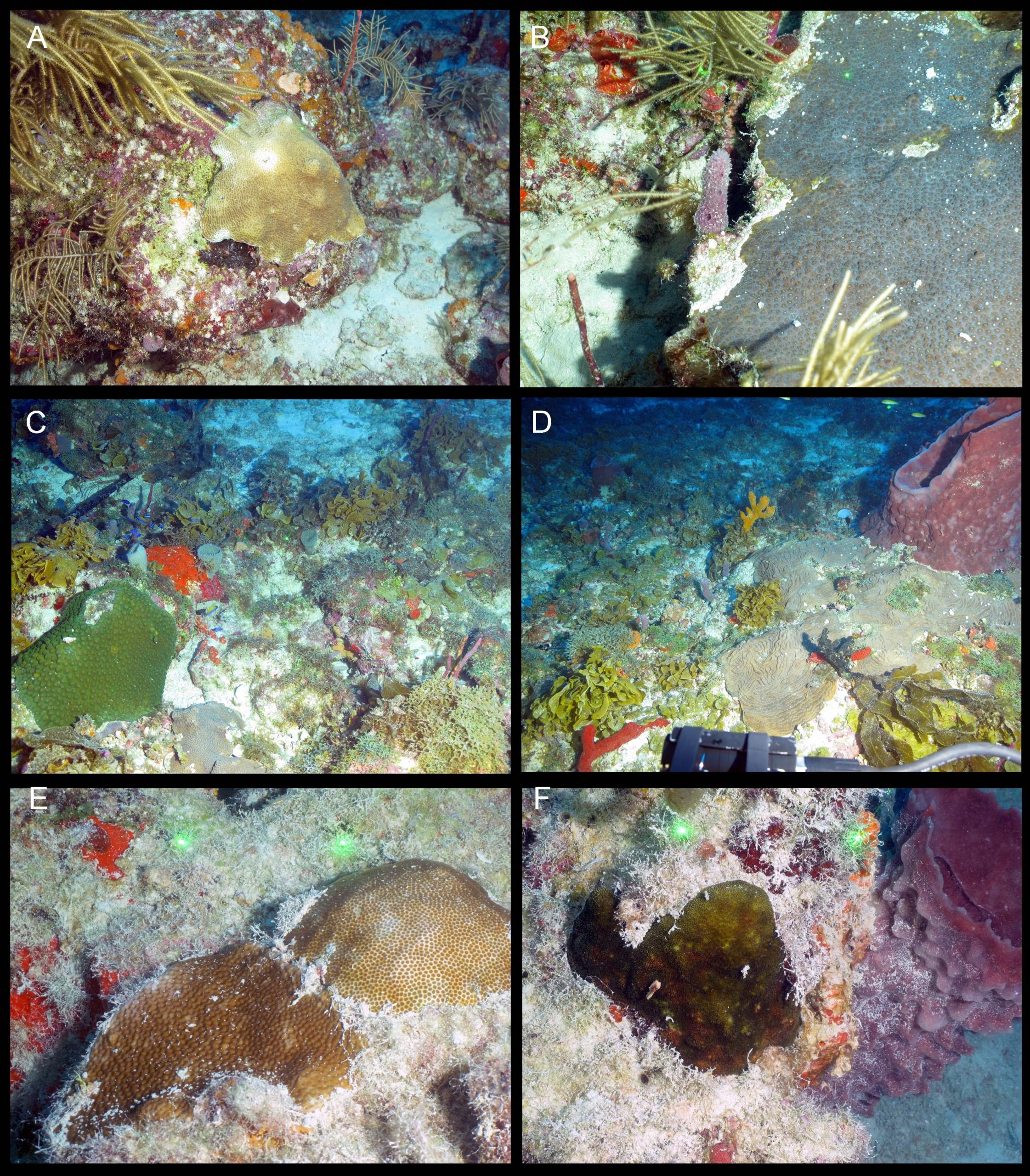
This 2016 Cruise Report provides detailed quantitative characterization of the benthic habitat, benthic macro-biota, and fish populations for each of the 23 ROV dives completed. Appendix 1 provides a species list and percent cover of benthic biota observed at each dive site. Appendix 2 provides a species list and densities of fish species observed at each dive site. Appendix 3 provides a SEADESC Level II Report for each dive site.
- The SEADESC Level II report includes:
- cruise and ROV dive metadata and objectives
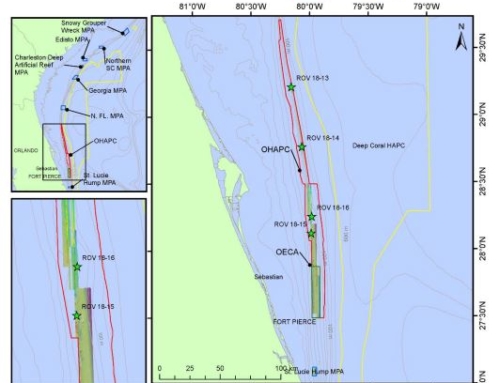
- figures showing each ROV dive track on multibeam sonar maps
- ROV dive track data (start and end coordinates, time, and depth)
- CTD plots from shipboard casts and temperature profiles for each ROV dive
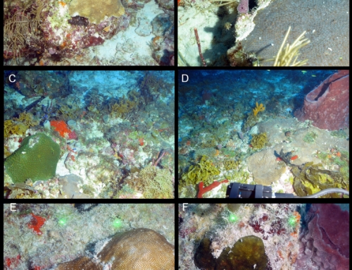
- images characterizing the habitat and biota for each dive site
- characterization of habitat, benthic biota, and fish populations for each dive site
- quantitative analyses of photo transects for each dive site of benthic habitat and biota
- quantitative analyses of video transects for each dive site of fish densities.
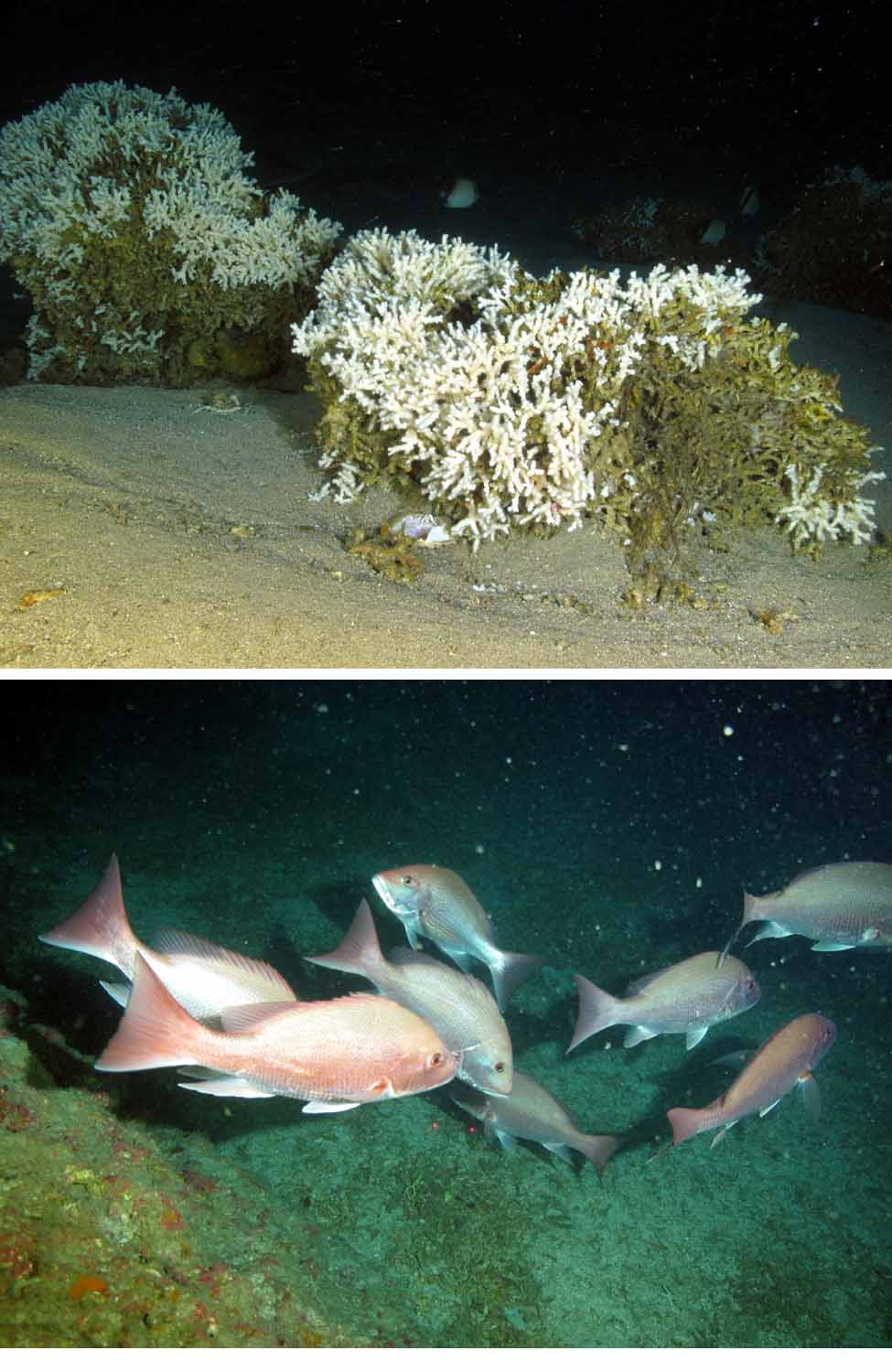
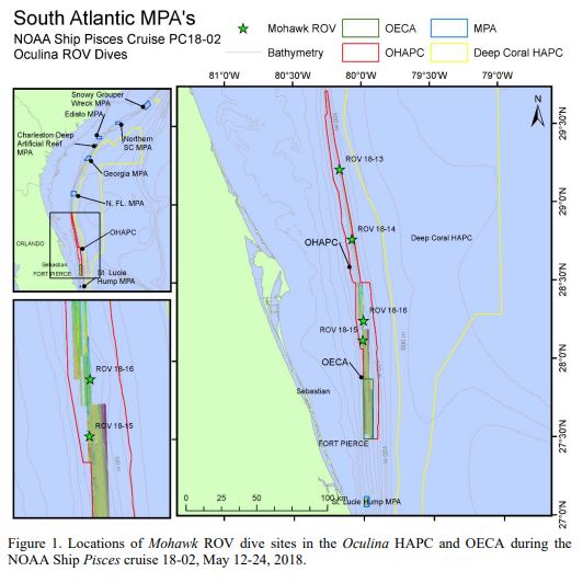
Twenty-three ROV dives were conducted resulting in a total bottom time of 57.5 hours, covering 26.8 km, at depths from 41 to 260 m. A total of 4,199 in situ digital images were taken which included quantitative transect images, general habitat, and species documentation images. Twelve shipboard CTD casts were made and a temperature/depth sensor recorded each ROV dive (Appendix 3). The multibeam sonar (ME-70) was used to map 9 areas including inside the Oculina OECA and covering a total area of 203.3 km2 . Of particular interest was the discovery of living Oculina coral thickets and coral mounds at the St. Lucie Hump MPA site, which was surveyed for the first time during this cruise. These are now the only know Oculina coral mounds in the world outside of the Oculina HAPC.
The data from this cruise will be combined with previous cruise data collected to characterize and document the habitat, benthic communities, and fish populations within the shelf-edge MPAs along the southeastern U.S. from North Carolina to south Florida. These data establish baseline information to be referenced and compared to future research cruises to identify the long-term health and status of these important ecosystems. These data will be made available to the SAFMC, NOAA Fisheries, NOAA DSCRTP, NOAA CRCP, NOAA Mesophotic Reef 3 Ecosystem Program, and NOAA Marine Sanctuaries to assist management on these habitats and key species.
Harter, Stacey, John Reed, Stephanie Farrington, and Andy David. 2016. South Atlantic MPAs and Oculina HAPC: Characterization of benthic habitat and biota. NOAA Ship Pisces Cruise 16-02. NOAA CIOERT Cruise Report, 270 pp. Harbor Branch Oceanographic Technical Report Number 181.